skip to main | skip to sidebar

Friday, June 6, 2008

Isohyets


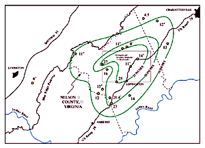
An Isohyet is an isoline that is used on weather maps to connect points that receive equal rainfall. This map uses Isohyets to show the total rainfall from Hurricane Camille in Nelson County, Virginia for the days of August 19 and 20, 1969. Rainfall measurements are in inches.
Posted by MB at 8:23 AM

No comments:

Post a Comment

Newer Post Older Post Home
Subscribe to: Post Comments (Atom)

Map Catalogue

Blog Archive

  • ▼  2008 (56)
    • ►  July (10)
    • ▼  June (28)
      • Population Profile
      • Scatterplot
      • Index Value Plot
      • Accululated Line Graph (Lorenz Curve)
      • Bilateral Graph
      • Nominal Area Choropleth
      • Unstandardized Choropleth Map
      • Standardized Choropleth Map
      • Remote Sensing
      • Bivariate Choropleth Map
      • Univariate Choropleth Map
      • Unclassed Choropleth Map
      • Classed Choropleth Map
      • Range-Graded Proportional Circle Map
      • Continuously Variable Proportional Circle Map
      • DOQQs
      • DEM
      • DLG
      • Isopachs
      • DRG
      • Isopleths
      • Isohyets
      • Isotachs
      • Isobars
      • LIDAR
      • Doppler Radar
      • Black and White Aerial Photography
      • Infrared Aerial Photograph
    • ►  May (18)

About Me

MB
View my complete profile