skip to main
|
skip to sidebar
Monday, June 23, 2008
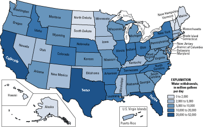
Unstandardized Choropleth Map
Unstandardized Choropleths portray areal data without averaging within specified units. The data is presented as a total value. The map above is shows total water use per day by state in the US.
No comments:
Post a Comment
Newer Post
Older Post
Home
Subscribe to:
Post Comments (Atom)
Map Catalogue
Blog Archive
▼
2008
(56)
►
July
(10)
▼
June
(28)
Population Profile
Scatterplot
Index Value Plot
Accululated Line Graph (Lorenz Curve)
Bilateral Graph
Nominal Area Choropleth
Unstandardized Choropleth Map
Standardized Choropleth Map
Remote Sensing
Bivariate Choropleth Map
Univariate Choropleth Map
Unclassed Choropleth Map
Classed Choropleth Map
Range-Graded Proportional Circle Map
Continuously Variable Proportional Circle Map
DOQQs
DEM
DLG
Isopachs
DRG
Isopleths
Isohyets
Isotachs
Isobars
LIDAR
Doppler Radar
Black and White Aerial Photography
Infrared Aerial Photograph
►
May
(18)
About Me
MB
View my complete profile
No comments:
Post a Comment